Post Code cancellations with 'Two Tiny Triangles'
Every collector of Austria is now familiar with the modern form of regular postmarks issued after the 4-digit post code numbers were introduced on January 1, 1966. The first cancellers (our type P1) reached offices in Vienna at the end of January, but it took till the 14th of October to complete the coverage of all of Austria. They had (and as today's type P3 still have) a single circle, the name of the post office in the upper part, underneath it one or two letters or a combination of figures and letters to distinguish between the different cancellation devices used, the date and time in several (P1, P2) or one (P3) horizontal lines across the centre of the circle, and finally in large figures the postal code number of the respective Post Office.

However, among the 2384 (in April 1998) regular Post Offices in Austria there are 82 that deviate slightly from the normal pattern of postmarks. They can be distinguished by two tiny equilateral triangles, approximately 1 mm high, which are found to the left and to the right and just above the postal code number, with the triangles standing on their point and filled in solidly.
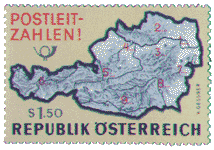
To explain the significance of these triangles we must first look at the structure of the postal code numbers. The first figure is called the leading (or routing) zone figure ('Leitzone') and normally it indicates the federal province in which the post office is situated. A commemorative stamp was issued (ANK 1231, 14 Jan 1966), depicting a map showing the zones.
The nine Zones:
- Vienna
- Lower Austria (east & south)
- Lower Austria (west & north)
- Upper Austria
- Salzburg
- Tirol & Vorarlberg
- Burgenland
- Styria
- Carinthia (and Eastern Tirol)
Lower Austria was divided into two parts according to the railway lines used! The second digit of the post code gives the routing area, the third the section, and the fourth the individual post office. In the case of Vienna, the second & third figures indicate the district (eg 10th district is 1100) except for the codes from 1300 upwards reserved for special uses such as the United Nations.
There are however a few exceptions, when a post office is situated such that its natural communications lead to a routing zone in a province different from the one in which it is itself located. For instance, the district of 'Eastern Tirol' is now completely separated from Tirol proper, after the ceding of Southern Tirol to Italy by the treaty of St Germain at the end of World War I. Although politically still part of Tirol, Eastern Tirol has much easier communication links to the province of Carinthia; therefore all post offices of Eastern Tirol have a postal code number that starts with '9' (Carinthia) rather than '6' (Tirol and Vorarlberg). Likewise the post office of St. Valentin in Lower Austria, having much closer communication links with Linz, the capital of Upper Austria, and being situated near the border of Upper Austria, carries the postal code number 4300 in spite of the fact that it is located in Lower Austria. Such exceptions from the general rule are indicated by those two tiny triangles and they therefore tell the postal clerk (and us as well) that the first digit of the post code is not identical with the 'leading zone figure' of the federal province in which the post office is located.
As an aside, it is unclear what practical use the triangles have anyway! Thus, the postmen in Lienz know that their mail goes out, and presumably comes in, via Karnten; this is quite clear from the postcodes 99--. Likewise, sorters whether manual or machine will separate mail by this 99-- code, and Herr Einer won't write triangles in the address! We conclude that the presence of the triangles is solely to prevent public outrage against the apparent assignment of East Tirol to Carinthia by giving it a postcode beginning with a 9 instead of a 6. The problem for collectors, that when the impression or the inking is feeble it is often very difficult to distinguish the triangles from the underlying design of the stamp, is just Life!.
A table of 'triangle' postmarks was derived from the 1998 official index of all Austrian postcodes (the Postleitzahlenversichnis) and follows.
| Burgenland with leading figure 2, which normally denotes Lower Austria |
| 2421 | Kittsee | 2473 | Potzneusiedl |
| 2422 | Pama | 2474 | Gattendorf |
| 2423 | Deutsch Jahrndorf | 2475 | Neudorf bei Parndorf |
| 2424 | Zurndorf | 2491 | Neufeld an der Leitha |
| 2425 | Nickelsdorf, Leitha | | |
| Upper Austria with leading figure 3, which normally denotes Lower Austria |
| 3334 | Gaflenz | 3335 | Weyer, Oberösterreich |
| Lower Austria with leading figure 4, normally Upper Austria |
| 4300 | St. Valentin, Niederösterreich | 4432 | Ernsthofen, Niederösterreich |
| 4303 | St. Pantaleon, Niederösterreich | 4441 | Behamberg |
| 4392 | Dorfstetten | 4482 | Ennsdorf bei Enns |
| 4431 | Haidershofen | | |
| Upper Austria with leading figure 5, which normally denotes Salzburg |
| 5120 | St. Pantaleon, Oberösterreich | 5232 | Kirchberg bei Mattighofen |
| 5121 | Ostermiething | 5233 | Pischelsdorf am Engelbach |
| 5122 | Ach | 5241 | Maria Schmolln |
| 5131 | Franking | 5242 | St. Johann am Walde |
| 5132 | Geretsberg | 5251 | Höhnhart |
| 5133 | Gilgenberg am Weilhart | 5252 | Aspach, Innkreis |
| 5134 | Schwand im Innkreis | 5261 | Uttendorf, Oberösterreich |
| 5141 | Moosdorf | 5270 | Mauerkirchen |
| 5142 | Eggelsberg | 5271 | Moosbach bei Mauerkirchen |
| 5143 | Feldkirchen bel Mattighofen | 5272 | Treubach |
| 5144 | Handenberg | 5273 | Roßbach bei Mauerkirchen |
| 5145 | Neukirchen an der Enknach | 5274 | Burgkirchen, Oberösterreich |
| 5211 | Friedburg | 5280 | Braunau am Inn, Bahnhofstraße 32 |
| 5212 | Schneegattern | 5282 | Braunau am Inn - Ranshofen |
| 5221 | Lochen | 5283 | Braunau am Inn, Salzburger Straße 88 |
| 5222 | Munderfing | 5310 | Mondsee |
| 5230 | Mattighofen | 5311 | Loibichl |
| 5231 | Schalchen, Oberösterreich | 5360 | St. Wolfgang im Salzkammergut |
| Styria with leading figure 7, which normally denotes Burgenland |
| 7421 | Tauchen-Schaueregg | | |
| Burgenland with leading figure 8, which normally denotes Styria |
| 8380 | Jennersdorf | 8384 | Minihof-Liebau |
| 8382 | Mogersdorf | 8385 | Neuhaus am Klausenbach |
| 8383 | St. Martin an der Raab | | |
| Styria with leading figure 9, which normally denotes Carinthia |
| 9323 | Wildbad Einöd | | |
| East Tirol with leading figure 9, which normally denotes Carinthia |
| 9782 | Nikolsdorf | 9953 | Huben, Osttirol |
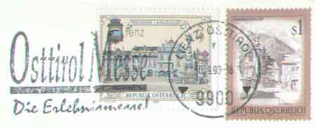
| 9900 | Lienz, Osttirol | 9961 | Hopfgarten in Defereggen |
| 9911 | Thal-Assling | 9962 | St. Veit in Defereggen |
| 9912 | Mittewald an der Drau | 9963 | St. Jakob in Defereggen |
| 9913 | Abfaltersbach | 9971 | Matrei in Osttirol |
| 9920 | Sillian | 9972 | Virgen, Osttirol |
| 9931 | Außervillgraten | 9974 | Prägraten |
| 9932 | Innervillgraten | 9981 | Kals am Großglockner |
| 9941 | Kartitsch | 9990 | Nußdorf-Debant |
| 9942 | Obertilliach | 9991 | Dölsach |
| 9951 | Ainet | | |
©Andy Taylor. Last updated 3 Jan 2014